February 13, 2024
OC Global Conducting a Demonstration Experiment of a Lane-specific Road Surface Condition Information Service Utilizing the Quasi-Zenith Satellite System ‘Michibiki’ in the Philippines
Oriental Consultants Global Co., Ltd. and Pacific Consultants Co., Ltd. (Headquarters: 3-22 Kanda Nishikicho, Chiyoda-ku, Tokyo; President and CEO: Osamu Omo) conducted a demonstration experiment of a lane-specific road surface information service for general vehicles using the “Michibiki” Quasi-Zenith Satellite System in the Philippines. The companies are currently assessing the feasibility of implementing the service and conducted a demonstration experiment in Manila in February 2024.
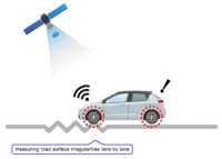
Road Surface Measurement with “Michibiki”

Vehicle Operation during the Demonstration Experiment
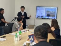
Press conference
Michibiki is Japan’s satellite positioning system primarily composed of quasi-zenith orbit satellites. It complements the commonly used GPS (Global Positioning System) in applications such as pinpointing locations on smartphone map apps. The system provides cost-effective, high-precision, and stable satellite positioning services, as the orbits are positioned to ensure that one satellite is almost directly overhead over Japan at all times. Michibiki is not just limited to Japan however, as it can be utilized in the Asia-Pacific region. Consequently, new business opportunities leveraging Michibiki in the region are anticipated.
In the Philippines, ensuring safe and comfortable road usage requires proper inspection and maintenance of road surfaces by road administrators. However, sustaining these efforts poses a challenge due to the associated maintenance costs. This service utilizes Michibiki and vehicle-mounted sensors to measure centimeter-level accurate location information and road surface irregularities efficiently. It detects damaged areas like potholes without the need for expensive specialized equipment. Collecting lane-specific road surface information using Michibiki not only reduces inspection costs by lane but also optimizes the timing of repairs, contributing to overall maintenance cost reduction by predicting road degradation.
In this demonstration, OC Global collaborated with NLEX Corporation, the construction and operation company for three major highways connecting Metro Manila with Northern and Central Luzon. Following the initial test in October 2023, a second field test was conducted in February 2024. The analysis focused on the relationship between driving data using Michibiki and the International Roughness Index (IRI), an indicator evaluating driver comfort measured by NLEX. Correlations between the driving data and IRI from October 2023 were verified, laying the groundwork for the service’s practical application.
Furthermore, Michibiki can acquire high-precision elevation data in addition to latitude and longitude. This capability allows identification of low-road points, aiding in recognizing flood-prone routes and presenting opportunities for new disaster prevention services.
Moving forward, based on the results of the demonstration, efforts will be made towards the practical implementation of this service. OC Global will continue investigations to introduce Japan’s Michibiki as a digital service solution to contribute to achieving secure and safe mobility in the Philippines.
*This demonstration project is being conducted as a commissioned task by the Ministry of Internal Affairs and Communications of Japan (Project title: Investigation and outsourcing for the verification and business deployment of systems contributing to safety and security in the mobility field utilizing quasi-zenith satellite systems in the Asia-Pacific region).
OC Global aims to promote the expansion of Japan’s satellite positioning system in the Asia-Pacific region, contributing to the realization of secure and safe mobility (SDGs 8, 9, 11).
![]()
![]()
![]()